
Trace a Barnstable County Street
A street-by-street record trail is strongest when it follows one property instead of treating a road as a list of current people. The county has 15 towns, while the Town of Barnstable has its own assessing and mapping systems. Begin by confirming the legal town and the full street address. The assessor and GIS records connect a house number to a parcel or map reference. The Registry then connects the displayed owner or parcel description to recorded instruments. Those sources establish different things, so keep their dates separate. A deed party is not automatically an occupant, and an assessor owner is not automatically the person living at the property.
- Use the local assessor or GIS address search to confirm the house number, street, legal town, parcel reference, and fiscal-year context.
- Save the displayed owner name, then search it as both grantor and grantee in the Barnstable County Registry of Deeds public access system.
- Try the Registry address index for a recent lead, noting that its address data starts in August 1993 and is described as unofficial and incomplete.
- Compare plans, lots, and recorded descriptions with the GIS parcel view before treating two similar street labels as the same place.
- For an older household question, use a dated directory, map, probate source, or local-history index rather than projecting a current property record backward.
That sequence keeps an address search tied to source dates. A town election office, where appropriate, is the custodian for public voter-list requests; the statewide status tool is intended for a voter checking their own registration.
Normalize Barnstable County Addresses
Street spelling is only one part of an address search. Barnstable County records may use a village or post-office name where another source uses the legal town. The Town of Barnstable GIS instructions use a street-name selection and then a house-number selection, which reduces suffix and spelling conflicts. For a condominium, boatslip, timeshare, or large parcel, the useful identifier may be a unit, lot, plan, or map/block/lot rather than the street number. Keep the ZIP and village as search aids, but retain the town returned by the assessor or Registry.
| Street address | Start with the number and street, then preserve the suffix and any unit or lot. |
|---|---|
| Legal town | Use the town that holds the assessor, clerk, and tax record. |
| Village or postal name | Useful for finding historical entries, but not a substitute for the legal town. |
| Parcel or map/block/lot | A more durable property join key than a street spelling. |
| Source date | Shows whether a field reflects a fiscal year, a map service, a recording, or a directory publication. |
- Parcel
- The assessor's mapped property unit, often the best join between an address, a plan, and a tax record.
- Situs address
- The physical property address, which can differ from a mailing or post-office address.
- Plat or plan
- A recorded map that can describe lots, bounds, units, or subdivisions without identifying an occupant.
- Criss-cross directory
- A historical directory organized by street or address rather than only by personal name.
Use the Registry villages table when postal wording is unclear. It identifies village, town, and ZIP combinations across the county. Note: a changed street number or map identifier calls for plans and deeds, not a guess based on a modern mailing label.
No official countywide historical street-name crosswalk or complete road-renumbering index was located in the research. When an older deed or directory does not match a current address, ask the relevant town assessor, GIS office, or historical society for an old and new street-name crosswalk. Search the street root, village, nearby cross street, business name, and parcel description where the record supports those alternatives. Preserve both forms in the research log instead of deciding that they are identical before the parcel or plan connects them.
Barnstable County Parcel and GIS Clues
The Town of Barnstable Department of Assessing lookup is a town-specific tool, not a countywide assessor. Its inspected form offers Map/Block/Lot, Owner Last Name, and Street Address groups. Each accepts full or partial input. No ZIP search field was found. The companion GIS viewer can find a property by parcel number or address and displays detailed assessor data after it locates the parcel. For streets elsewhere in Barnstable County, start with the relevant town’s assessor and GIS office rather than assuming the Town of Barnstable portal covers all 15 towns.
| Search group | Fields observed | Best use | Limit |
|---|---|---|---|
| Map/Block/Lot | Full or partial map, block, and lot together | Match a deed or plan to a parcel | Town-specific assessor data |
| Owner | Full or partial last name | Move from the parcel display to Registry name research | Does not prove occupancy |
| Street Address | Full or partial street number and street name | Locate an address and parcel reference | No ZIP control was exposed |
The Town of Barnstable GIS property viewer is shown below with its parcel and map navigation controls.
Its parcel, road, building, abutter, zoning, and town-boundary layers supply geographic context. The online parcel lines are graphic representations, not legal boundary evidence or a survey.
Search the Barnstable County Address Index
The Registry address search accepts a partial property address, document types, towns, and a date range across Recorded and Registered Land. It is a useful address-search lead, but the Registry says the address index begins in August 1993 and is neither verified nor complete. Start with a partial street root if the full form fails. The Registry specifically advises omitting a suffix or the first letter when needed. Follow an address hit with an owner-name search and inspect the instrument details rather than treating the address result as a title conclusion.
The official Registry address-search form shows the town, document-type, and date controls used for that preliminary search.
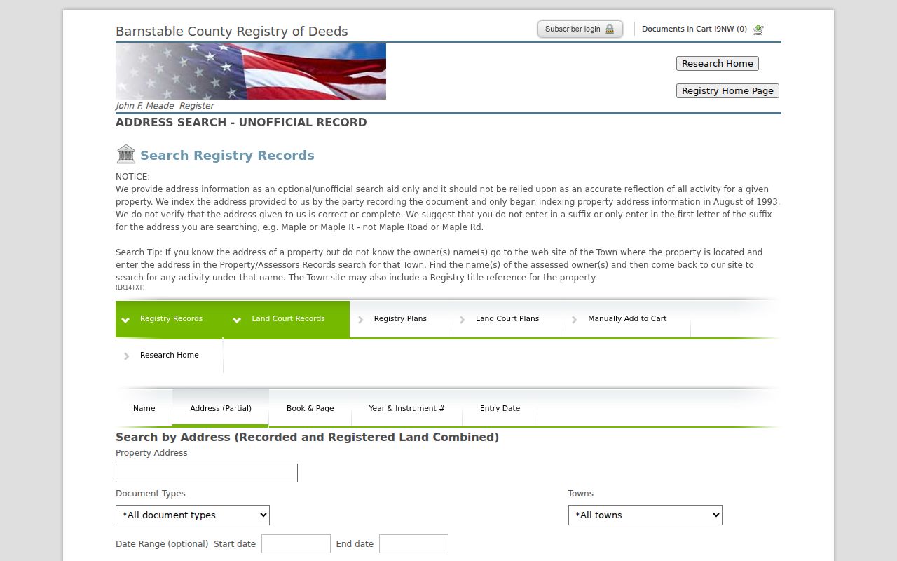
When the address route stalls, go back to the assessor owner display and use the Registry name form. Name searches support grantor and grantee roles, town, document type, and date or index windows.
Barnstable County Town Books After 1827
The 1827 Barnstable courthouse fire is a key break in an early address trail. All but one of 94 deed volumes were destroyed. A 1828 statute authorized temporary town registries and the re-recording of deeds for a limited period, creating the Town Books that survive today. A property history that jumps into a Town Book, later recorded instrument, or Land Court file may reflect this custody history rather than a missing owner. Land Court has its own record track, and the Registry notes that its name index is incomplete even though Land Court images reach from 1899 onward.
The Registry research home separates Recorded Land, Land Court, plan, and address-search routes.
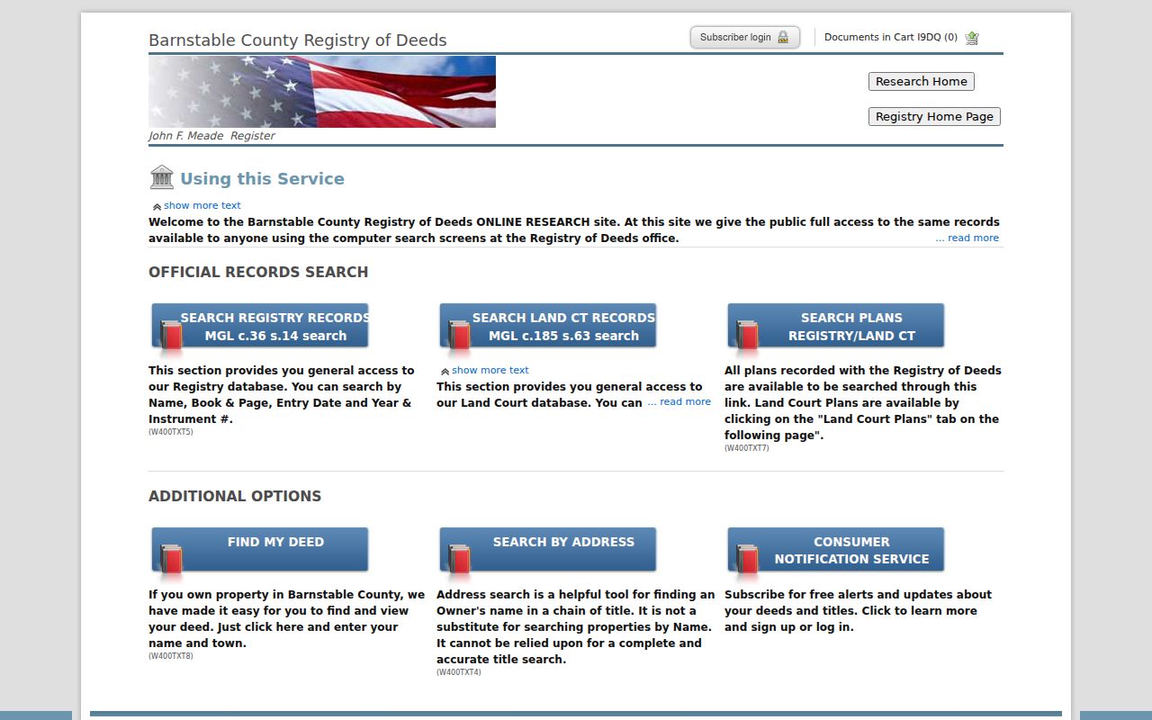
Use the record label in your notes. A recording date, a Town Book copy date, and an image-access date can describe separate events in the same long property trail.
Barnstable County Street Records Compared
Address-keyed sources answer different questions. A well-supported address record trail keeps the relationship visible instead of blending owner, parcel, voter, and map fields into one claim. The Registry covers countywide recorded land across 15 towns. Local assessing, mapping, election, and permit systems remain town-specific. The Town of Barnstable building page reports that its former View Permit system moved to OpenGov Permitting, Licensing, and Code Enforcement, with earlier applications, inspections, and permits migrated. Its live search fields were not verified in the research, and a completed status is not necessarily final sign-off.
| Address source | Custodian | What it can establish | Access route |
|---|---|---|---|
| Assessment record | Relevant town assessor | Parcel association, owner display, fiscal-year context | Town lookup or office |
| GIS property map | Relevant town GIS office | Parcel, road, building, and nearby parcel geography | Public viewer where available |
| Recorded instrument | Barnstable County Registry of Deeds | Recorded parties, document type, town, date, book/page or instrument | Free index and on-screen image research |
| Street list or voter list | Town election office | Publicly releasable voter fields for the requested list year | Request local list and accept redactions |
| Permit or inspection record | Relevant town department | Property, permit, application, inspection, or code context | Portal, account, or narrowly described records request |
For a broad address-history request, ask the local custodian for property cards, permits, inspections, and publicly releasable address or parcel records for the exact address, town, and date range. The county public-record guidelines explain the Massachusetts request process for county-held records; a town maintains its own records too.
For Registry material, indexes and on-screen images are free to view. A clean printed image costs $1 per page plus the portal card convenience fee. The Registry does not perform title searches or give legal advice, so use book/page, instrument number, image page, recording date, and document type as citation details rather than calling the resulting sequence a title opinion. A discharge, plan, lien, or court order has a different purpose from a deed and should be read in context.
Historical Barnstable County Street Listings
Modern parcels do not replace the older street sources. The State Library notes that directories may be alphabetic, business-focused, or arranged by street, while the 1901 Cape Cod directory contains resident and street material. A dated street listing can show a household or business at the publication date, but rural, seasonal, and boarding-house coverage may be incomplete. The Library of Congress 1906 Hyannis Sanborn sheets add building footprints, uses, street alignment, and nearby features. Use a map to interpret a directory entry, not to claim ownership or full occupancy.
Whelden Memorial Library’s local index links West Barnstable people, homes, businesses, organizations, cemeteries, and events. That index and Sturgis Library collections can extend a people-and-place trail, while the historical volumes themselves belong on the Barnstable County city directory page.
Start an older street trail with a publication year, then add a map year and a document date. The 1901 Digital Commonwealth object is concentrated in six Outer Cape towns, so its Cape-wide title is not proof that an entry exists for every county town. The State Library lists Barnstable directories for 1895, 1901, and 1926, while NARA identifies countywide Barnstable/Falmouth holdings for 1903, 1908, 1926, and 1929. Check town coverage before interpreting a no-result as an absence.
Note: a historical street absence can reflect uneven publication coverage, a village heading, a route name, or an abbreviated suffix.
Barnstable County Permit History
Permit and inspection systems can add a dated property event to a street trail. For the Town of Barnstable, the former View Permit system was upgraded to OpenGov Permitting, Licensing, and Code Enforcement, and earlier applications, inspections, and permits were migrated. The public landing page did not expose a verified field list or stable result capture. A new account may be required, and a broad history may need a focused public-record request. A completed status is not necessarily a final sign-off, so keep the permit number, property, status date, and custodian with the result.
Request only the record class needed. A narrow request for property cards, permits, inspections, and publicly releasable address or parcel material gives the custodian an address, town, and date range to evaluate. It also makes clear that exempt personal information should be excluded. That approach is more reliable than asking an office to assemble a general history of people connected to a street.
Barnstable County Plan and Lot Records
Plans, lots, condominiums, and maritime interests can interrupt a street-number search. The Registry’s document list includes plans, plan-plus-square-foot variants, boatslip assignments, timeshare deeds, and timeshare licenses. A plan can divide or describe land without naming an occupant. Match it to the deed that cites the plan and to the assessor parcel map. If a property is recorded under a unit, lot, or slip, keep that designation in the address research notes instead of forcing it into a conventional address format.
Recorded Land and Land Court are separate tracks. Older Land Court certificates are scanned originals before certificate number 130989, while later activity uses an electronic run-down. Search both routes when the address chain stops. The person or entity in an instrument is a recorded party, and the document still needs to be read before drawing a conclusion about a parcel.
Limits of a Barnstable County Street Directory
Public records can describe a parcel, a recorded transfer, a published directory entry, or a public voter-list field. They do not create a complete, current household roster. Massachusetts voter information has protected categories, including confidential voters and minors, and the statewide status lookup is not a public countywide name database. The Address Confidentiality Program uses substitute addresses for eligible people and those addresses must not be reverse-engineered through parcel or deed matching. Missing data can be a privacy protection, not an error.
Lawful use. Barnstable County street records are for lawful, personal research. Do not use address information to stalk, harass, intimidate, or harm anyone.